Stuarts Point development
With the planned installation of the Stuarts Point Sewerage Scheme and the boom in housing demand on the Mid North Coast, Kempsey Shire Council is aware of interest among developers in the area.
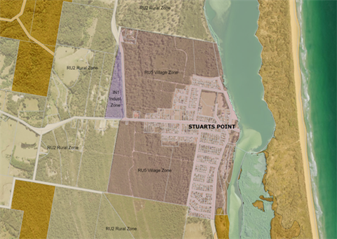
There is specific interest in areas to the North West and South West of Stuarts Point.
The majority of the land is zoned RU5 Village, being the land to the north and south of Ocean Avenue. There is also a small portion land zoned IN1 Industrial, located on the corner north-west of the intersection of Ocean Ave and Grassy Head Rd.
Zoning
The area in question is subject to historical zone patterns from several decades ago.
RU5 Village Zone
It permits many land uses that would be expected within a “village” area. Permitted land uses include:
- Various types of lower-density residential uses;
- Some uses that are adjacent to residential, such as seniors living and tourist;
- Some lower-tier commercial uses, such as shops and child care centres.
Prohibited land uses include
- Higher-density residential uses, such as residential flats;
- Higher-impact commercial and industrial uses.
IN1 Industrial Zone
This zone only permits industrial uses as well as industrial-adjacent uses, such as hardware supplies and warehousing.
For a detailed list of the permissible land-uses, and more information head to ksc.pub/klep
Council planning
A structure plan will be prepared for Stuarts Point to guide the future development of this village prior to the operation of the Stuarts Point Sewerage Scheme. (The Stuarts Point Sewerage Scheme is not expected to be delivered before 2025).
Structure Plans are created for identified as locations for growth to:
- Set out where and how this growth and development will occur
- Ensure development is located and managed appropriately; and
- Ensure that infrastructure and services will meet the needs of the current and future residents.
It would set out requirements for land use, building height, infrastructure, public spaces, and movement.
The Structure Plan will be prepared based on forecast demand, expected capacity, and government, community and stakeholder engagement.
Development Applications
Any development application must comply with the relevant local and state standards and guidelines.
Any substantial development will require approval from Council. As part of the development assessment process, any proposal will be subject to merits and statutory assessments.
Merits assessment
The involves a review of the local hazards, such as bushfire and flood, and constraints. It also includes assessment of impacts such as vegetation clearing and increased traffic.
Statutory assessment
This involves a review of local and state legislated planning schemes including the Kempsey Local Environmental Plan 2013 and any State Environmental Planning Policies that apply to the specific land uses and hazard types in question.
Advertising and Notification
All Development Applications are published on Council’s website (www.kempsey.nsw.gov.au), with links to relevant plans and documents provided.
For larger developments will also receive:
- Specific notice on Council’s website
- Notification letters sent to adjoining owners at a minimum, and to surrounding areas for proposals assessed to be of community interest.
Environmental and cultural values
The land in question is a greenfield site, which is to say it is presently undeveloped.
The area has significant environmental and coastal values.
Consideration of these values will occur through any Development Assessment process.